
Letting nature take the lead: Building resilience in the Logan catchment
Tucked within the Logan catchment at Rathdowney is a property with an important role to play in protecting South East Queensland’s drinking water supply due to its proximity to the intake for the local community’s water treatment plant.
Through the Seqwater-funded Multi Catchments Source Water Protection Project, this site is a great demonstration of how thoughtful, science-based management can support the health of our waterways.
Working closely with the landholder, this challenging waterway has become a valuable long term learning site, and our approach is building trust through landholder involvement while improving our understanding of erosion, land management and natural recovery.
By combining targeted action that enables natural processes, supported by careful monitoring, Healthy Land & Water is actively observing change and learning when to intervene intensively and when to take a lighter-touch approach to support nature’s ability to recover.
A site that’s taught us important lessons
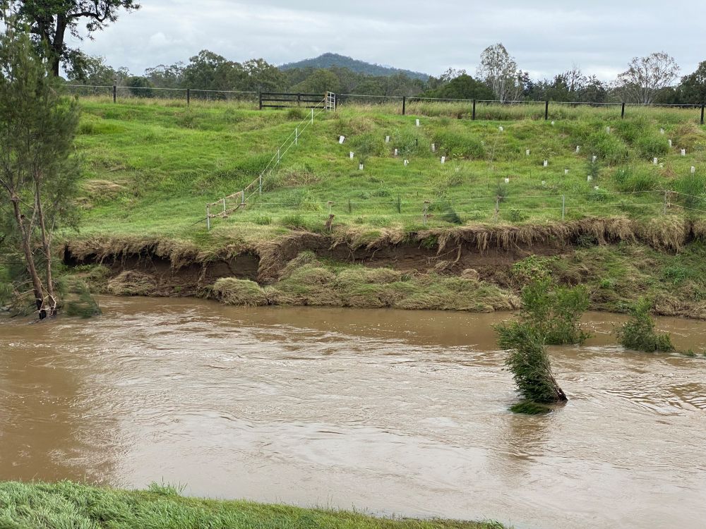
Over the years, this property has been a testing ground for building resilience and controlling erosion. Several approaches were trialled to stabilise the riverbank, including planting vegetation right down to the water’s edge and installing fencing. However, the challenging nature of this site, with its sandy soils and high velocity water flows, meant even minor flood events repeatedly washed these efforts away, leaving the bank vulnerable once again.
 |
 |
Caption: Regular flooding events at this site mean hard work to build site resilience is often washed away.
After a thorough technical assessment, it became clear that while traditional interventions weren't practical from a cost–benefit perspective, the site still offered valuable opportunities and that erosion would reduce in the longer term once deep-rooted vegetation was established – even if we lost some plants in the short term.
Rather than abandoning the site, the team shifted focus to harnessing natural processes to stabilise the area, closely monitoring how the land responds over time. This approach has delivered key learnings about effective strategies, limitations, and how ongoing data collection can support smarter, more resilient land management.
These key learnings include:
- High-energy riverbanks with sandy soils may not respond to repeated hard interventions; working with natural recovery processes can deliver better long-term outcomes.
- Toe stability is critical – loss at the toe drives undercutting, slumping and accelerated bank erosion.
- Short-term erosion or plant loss does not always indicate failure and may be part of a longer recovery trajectory.
- Simple but consistent monitoring, especially well-executed photo point monitoring, is essential for understanding change and guiding intervention.
- Site-specific conditions matter – data, not recipes, should drive decisions.
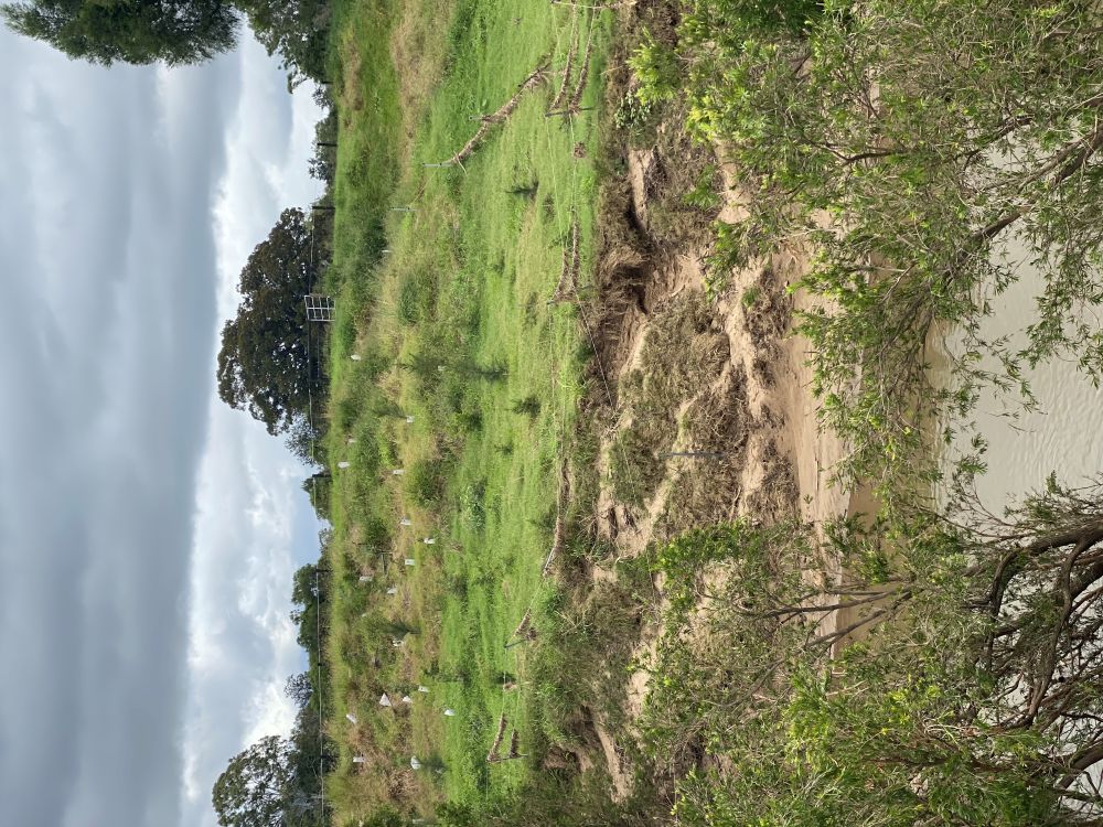
|
|
 |
Caption: Letting nature take the lead.
Observing change over time
Today, the site is closely monitored using photo point monitoring and scientific tools such as aerial and satellite tracking, allowing our team to track change over time and respond when intervention is needed.
Our monitoring has shown in this vulnerable sandy soil that erosion starts at the toe of the bank, which leads to small slumps throughout the area, enabling floods to gouge out larger sections of banks. A slump occurs when soil drops or collapses after being washed out from underneath and can be particularly problematic when deep-rooted vegetation such as trees are absent – a process that is evident at this site.
From plant growth and weed emergence to small slumps and erosion at the toe of the bank, this ongoing monitoring helps distinguish between what might look concerning and what is actually part of a healthy recovery process.
Photo point monitoring – a simple but effective tool
The photo point monitoring methodology is deliberately simple so it can be repeated easily. Monitoring photos are taken from the exact same location, with the same zoom and facing the same direction each time.
This allows changes to be clearly observed over time and helps determine the speed of change and whether conditions are improving or declining, and to support decision making whether further action is required.
Photo point monitoring methodology
Why photo point monitoring works:
- Is a permanent record of a site before, during and after works to keep track of works undertaken, promote the results of projects and to leverage further resources to support land managers and the broader community.
- Photo point monitoring is a quick, simple and reliable way of capturing short and long-term visual changes at a site, that may result from:
- Changed land management practices (including any trials).
- Climatic conditions.
- Natural events (e.g. flood, drought, fire).
- Demonstrate the effects of changed land management practice.
- Helps identify early signs of improvement or decline.
- Can trigger more detailed monitoring if needed.
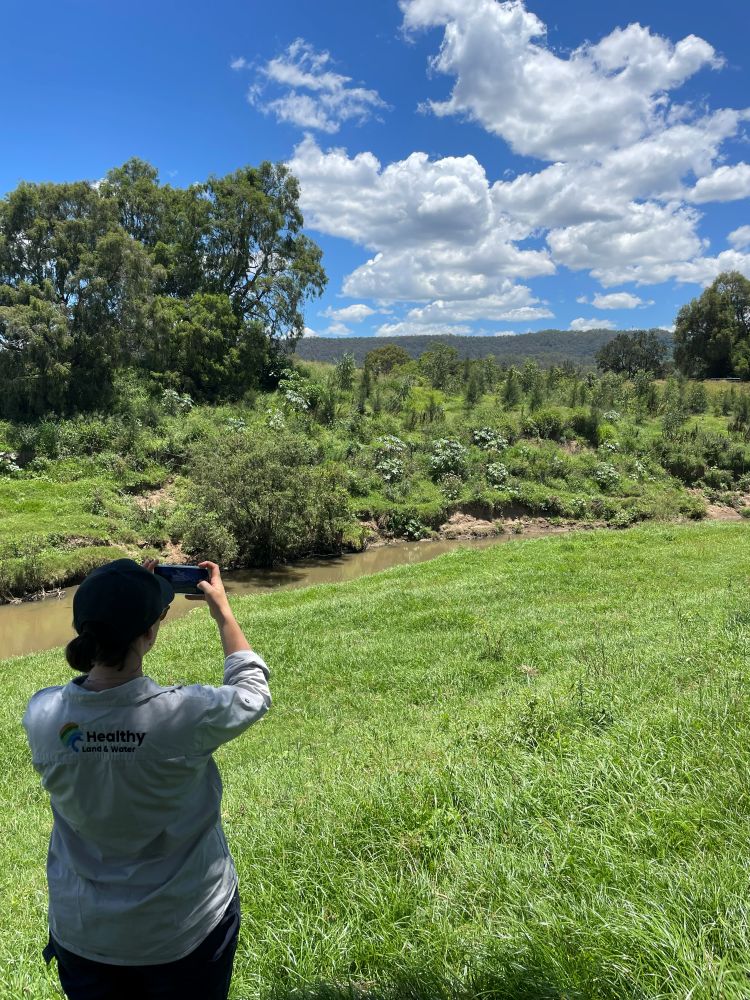 Caption: Project Officer, Grace Robertson, completing photo point monitoring activity at the Rathdowney site.
Next steps at this site
The site will continue to be monitored through photo point monitoring as well as aerial and satellite tracking. Supplementary planting is planned, particularly at the toe of the bank where erosion is occurring.
Planned actions include:
- Planting lomandras at the toe of the bank, as they establish their leaves quickly, helps keep fast water flows away from the soil while their roots help hold soil together.
- Allowing natural recruitment to grow on the toe.
- Stakes to protect plants.
- Seasonal planting to allow for proper establishment.
- Planting higher up the bank when feasible.
- Ongoing monitoring of smaller slumps, as vegetation matures.
Importantly, this property is a working example – not a one-size-fits-all solution. What works here may not work elsewhere. By sharing this story, we aim to build understanding, trust and engagement with landholders and the broader community, and highlight how data-driven decisions play a critical role in protecting our waterways and catchments.
Why is this program so important?
The Multi Catchment Source Water Protection Program, funded by Seqwater and led by Healthy Land & Water, works with landholders to protect the health and build the resilience of our region’s waterways and helps to ensure Seqwater’s water treatment plants can efficiently and cost-effectively turn raw water into clean, safe, treated drinking water for the community.
By reducing sediment and pathogen loads entering waterways, the project improves stream water quality while supporting a sustainable and resilient future for the Logan Albert, Warrill and Upper Brisbane catchments and their ecosystems.
This program is funded by and delivered in partnership with Seqwater.
